

Description
Garmin BlueChart g3 HD HXCA600X Canada microSD | Boat Supply Store
This electronic charting solution provides unparalleled detail for coastal and Great Lakes navigation across North America. It integrates industry-leading Garmin and Navionics® data, offering detailed features like up to 1' contours for precise bottom structure depiction. Coastal and Great Lakes boaters requiring advanced navigational assistance, such as calculating optimal routes for a fishing trip to Puget Sound, will find this essential.
Key Features
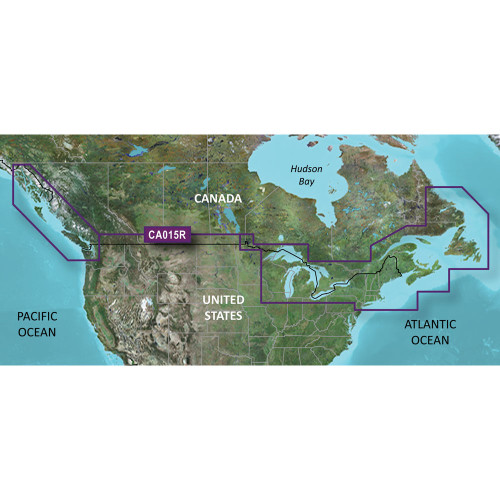
- Detailed coastal coverage of North America East Coast (Nain, NL to Raritan Bay, NY) and West Coast (Glacier Bay, AK to Aberdeen, WA)
- Full US and Canadian coverage of the Great Lakes
- Integrated Garmin and Navionics® data for superior accuracy
- Advanced Auto Guidance¹ technology for seamless route calculation
- Precise Depth Range Shading for up to 10 distinct depth ranges
- Accurate up to 1' contours for detailed bottom topography
- Customizable Shallow Water Shading for safe passage
- NOAA raster cartography compatibility via ActiveCaptain® app
Specifications
| Product Specifications | |
|---|---|
| Card Type | microSD™/SD™ |
| Coverage Area | North America East Coast (Nain, NL to Raritan Bay, NY), North America West Coast (Glacier Bay, AK to Aberdeen, WA), Full US & Canadian Great Lakes |
| Data Integration | Garmin and Navionics® data |
| Auto Guidance | Yes |
| Contour Detail | Up to 1' contours |
| Shallow Water Shading | Yes |
| NOAA Raster Cartography | Available via ActiveCaptain® app |
Who This Is For
Coastal and Great Lakes boaters, anglers, and navigators who demand highly detailed and current electronic charting. Ideal for those transiting waters from Nain, NL to Raritan Bay, NY, or navigating the complex shorelines of British Columbia and Puget Sound.
How It Compares
| Feature | Garmin BlueChart g3 HD HXCA600X Canada microSD | Competitor |
|---|---|---|
| Coverage Area | North America East Coast (Nain, NL to Raritan Bay, NY), North America West Coast (Glacier Bay, AK to Aberdeen, WA), Full US & Canadian Great Lakes | US East Coast, Canada East Coast, Great Lakes |
| Data Integration | Garmin and Navionics® | Navionics proprietary data, C-MAP proprietary data |
| Auto Routing Technology | Auto Guidance¹ | Autorouting, Dynamic Routing |
| Contour Detail | Up to 1' contours | Up to 1' contours, High-resolution bathymetry |
| NOAA Raster Cartography | Available via ActiveCaptain® app | null, null |
Common Concerns Answered
I have an older echoMAP CHIRP or ECHOMAP Plus combo; will I be able to view NOAA raster cartography?
No, specific chartplotter models, such as echoMAP CHIRP and ECHOMAP Plus combos, are not compatible with viewing NOAA raster cartography from this card. Always verify chartplotter compatibility for advanced features.
How reliable is the Auto Guidance technology for route planning?
Auto Guidance¹ technology provides efficient route calculation based on chart data, but it is recommended to always review and override the suggested route when necessary for safe navigation, as user discretion is paramount.
What is the process for enabling NOAA raster cartography?
Accessing NOAA raster cartography requires the use of the Garmin ActiveCaptain® app, which synchronizes with your chartplotter and the map card to enable this feature.
Frequently Asked Questions
What specific geographic areas does the Garmin BlueChart g3 HD - HXCA600X - Canada map card cover?
This map card provides detailed coastal coverage of the North American East Coast from Nain, NL to Raritan Bay, NY, and the North American West Coast from Glacier Bay, AK to Aberdeen, WA. It also includes full US and Canadian coverage of the Great Lakes.
Does this map card include Auto Guidance technology, and how does it work?
Yes, this map card features Auto Guidance¹ technology. It automatically calculates the best route to a destination based on chart data, depth, and navigational aids, guiding you along a programmed path.
What is Depth Range Shading and how can it benefit me?
Depth Range Shading visually highlights designated depth contours on the chart, allowing you to easily identify shallow areas and areas with depths suitable for your specific needs, enhancing situational awareness.
Are the 1' contours on this map card accurate enough for detailed fishing?
The up to 1' contours provide highly accurate bottom structure depiction, which is beneficial for detailed fishing by revealing subtle changes in underwater terrain and potential fish habitats.
Is this map card compatible with all Garmin chartplotters?
While this map card is designed for a wide range of compatible Garmin chartplotters, it is essential to verify specific model compatibility on Garmin's website or with a product specialist to ensure full functionality, especially for features like NOAA raster cartography.